|
|
|
|
|
|
|
|
Charles H. Hapgood was one of the most prominent researchers in the theory of sudden shifts of the outer crust of the earth and yet remains to a large degree obscure to the scientific establishment today. His research, however, is compelling and supports alternative theories about our past that could only be explained by sudden, cataclysmic events in the past. I have used three of the previous pole positions as established by the scientific study of paleomagnetism (ancient magnetic field orientation in rock) to show the locations of Egypt in each of the previous pole positions below. With the help of Google Earth (many thanks) and some simple editing, some interesting results have been obtained. These models are not exact and are only intended to view geographical locations as they would have appeared at different times within a reasonable amount of exactitude using the research set forth by Hapgood, et. al. They are close enough for our discussion here. Please also note that the date ranges (80,000-75,000 B.C.,55,000-50,000 B.C. and 17,000-12,000 B.C.) are when the shift into the next polar position occurred using paleomagnetic findings. Additional information about pole shifts can be obtained by reading Hapgood's, Path of the Pole and John White's Pole Shift.
|

|
|
|
|
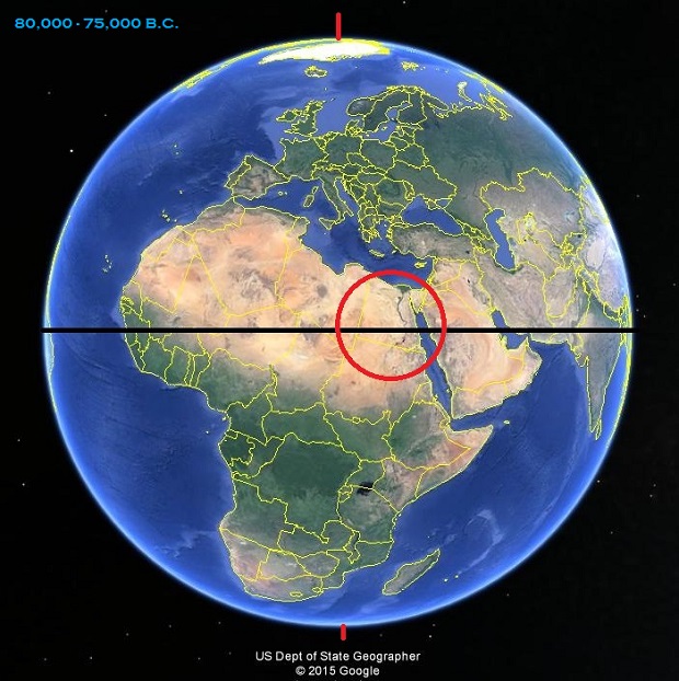
This model demonstrates a previous pole position in the date range of 80,000-75,000 B.C. (82,000-77,000 years ago) using paleomagnetism findings immediately before a polar shift into the position shown below. The north pole at this time would have been in the Yukon district of Canada. Note the location of Egypt. During this period of time, Egypt could have had lush vegetation and possibly more rainfall because of its location in an equatorial region. The entire northern portion of Africa would have enjoyed a tropical climate while countries such as Norway, Sweden, Finland and Iceland could have been partially covered in glacial ice. Was it the shift from this position to the one below that flash-froze wooly mammoths in Siberia with undigested butterups still in their mouths? Or was is the shift that occurred between 17,000-12,000 B.C. that did it? Carbon dating wooly mammoth at the moment seems to be a bit problematic and varies greatly even when parts of the same specimen are used. |
This polar displacement model demonstrates the position of the earth's axis at the time of 55,000-50,000 B.C. (57,000-52,000 years ago) just prior to another polar shift resulting in a new orientation of the earth depicted below. Again, note the position of Egypt. For 25,000-30,000 years, Egypt has been displaced a considerable distance to the north into latitudes that would rival the location of the British Isles today. Parts of northern Europe would have possibly been buried under glacial ice. The north pole at this time would have been the Greenland Sea. Mass migrations would have been inevitable from Scandanavia and Europe towards the warmer climates of Africa at this time. The 33,000-43,000 years between the orientation of the poles here and the next pole shift depicted below fits the timeline of the extinction of the Neanderthals and the Cro-Magnon races of man. |
|
|
|
| From our perspective, this pole position would have came to an end about 14,000-19,000 years ago. At this time, the north pole would have been in Hudson Bay in North America and most of this continent would have been covered by ice and the Wisconsin glacier for roughly 38,000-43,000 years. After this polar orientation changed sometime around 17,000-12,000 B.C., the Ice Age ended, the wooly mammoth supposedly became extinct and the great flood occurred. The earth settled once again into a new north and south pole orientation: the current one. |
This is the north and south pole positions as we know them today. It is interesting to note that using data derived from paleomagnetic study and the research performed by Hapgood's team, Egypt as well as Israel, ancient Sumer, the northern portion of Africa, the Sinai Peninsula and Turkey among others could have been continuously inhabited by man for more than 80,000 years. |
|
|
|
|
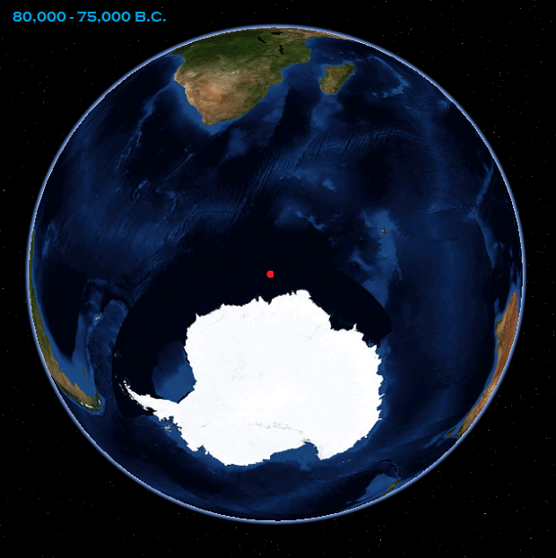
This is the location of the south pole as determined by paleomagnetism as it would have been until 80,000-75,000 B.C. (These images courtesy: Nasa World Wind) |
After 80,000-75,000 B.C., the south poles shifted into this position and remained here until 55,000-50,000 B.C. |
|
|
|
|
Between 55,000-50,000 B.C. and 17,000-12,000 B.C., the south pole remained in the position depicted above until this period ended with a shift of the poles culminating in the current pole position of today. The problem with
polar shifts changing positions of land masses on the planet (outside of the
obvious) is that astronomy does not take into consideration how the shifting of
the earth's poles and its axes changes our view of the cosmos. If paleomagnetic studies are
valid, this data must be integrated into astronomical mathematics so that the
positions of the stars in the ancient skies prior to about 14,000 years ago
could be corrected and viewed with accuracy. If we are to study astronomical
alignments of ancient structures that we suspect predate our own timeline, it is critical to study them using pole positions and axis orientations that fit their own timeline. If locations such as Gobeckli
Tepi and monuments such as the Great Sphinx are this old (or older), then it would be
advantageous to 'adjust' for the previous alignments of the poles and axes of the earth to study these
sites with polar alignments from within the period of their suspected
construction. |
The present day position of the south pole and Antarctica. Is this
massive, ice-laden area melting and then re-icing, cycling through increasing
and decreasing mass changes as it wobbles at the bottom of the planet playing a
major role in the triggering of polar shifts? When it loses a substantial
volume of its ice mass, is this 'anchor' loosed at the bottom of the earth to
swing out of kilter, throwing the earth out of balance until re-accumulation of
ice occurs in another region that establishes a new, stable south pole? A
few things are certain: the ice at the south pole is melting at an
alarming rate, weather pattern determination and the predictability of weather
is becoming more difficult, and the destruction associated with
catastrophic weather globally is becoming much more common and increasing in magnitude. The earth has also been visited in the past by meteors and comets that have left their marks on our planet. All one has to do is look at Mars and our moon to see that meteors and interstellar objects in the cosmos have used them as punching bags. We must strongly consider that meteors and comets striking the earth or coming into close proximity with the earth may have had a hand in triggering pole shifts. Click here to see information on the comet Shoemaker-Levy 9 when it collided with the planet Jupiter in 1994. |
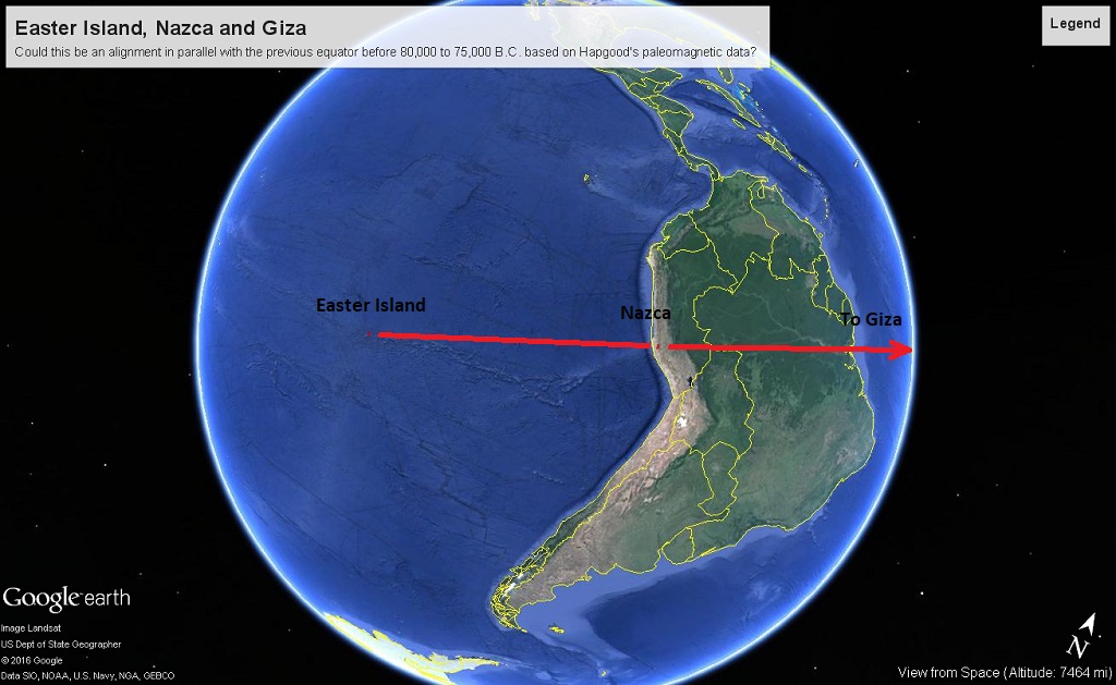
The Alignment of Easter Island, Nazca and Giza
|
|
|
While not exact, this accurate alignment model of Nazca and Giza also intersects Easter Island in the Pacific Ocean. What is truly intriguing is that it is extremely close to the equator of the earth around 80,000 to 75,000 B.C. as evidenced by paleomagnetic data in Charles Hapgood's research. |
|
|
|
There are other significant locations along this parallel that I haven't detailed here but this is sufficient to demonstrate the possible cohesion of this geographical alignment and the validity of paleomagnetic findings outlined by Hapgood, et. al. |
|
|
|
|
|
|
|
|
|
|
|
|